Footprint Map
 evanwong92 downloads
Render local photo footprints as interactive time-ordered maps.
- Overview
- Scorecard
- Updates6
Footprint Map renders a local, time-ordered travel diary from photo locations inside Obsidian. It keeps the footprint data in portable GeoJSON, links each place to local photos, and draws dashed straight arrows to show visit order—not the route actually travelled.
中文说明见 简体中文。
Quick start
- Install and enable the Footprint Map plugin.
- Open the Obsidian note where you want to generate a Footprint Map.
- Place the cursor where the map should appear. Press
Command + P, search forFootprint, and select Footprint Map: Generate footprint from photos in the current note. The generated map block is inserted at that cursor position.
Notes
The following images may not appear in the Footprint Map:
- Images downloaded from the internet.
- Photos taken without location information enabled.
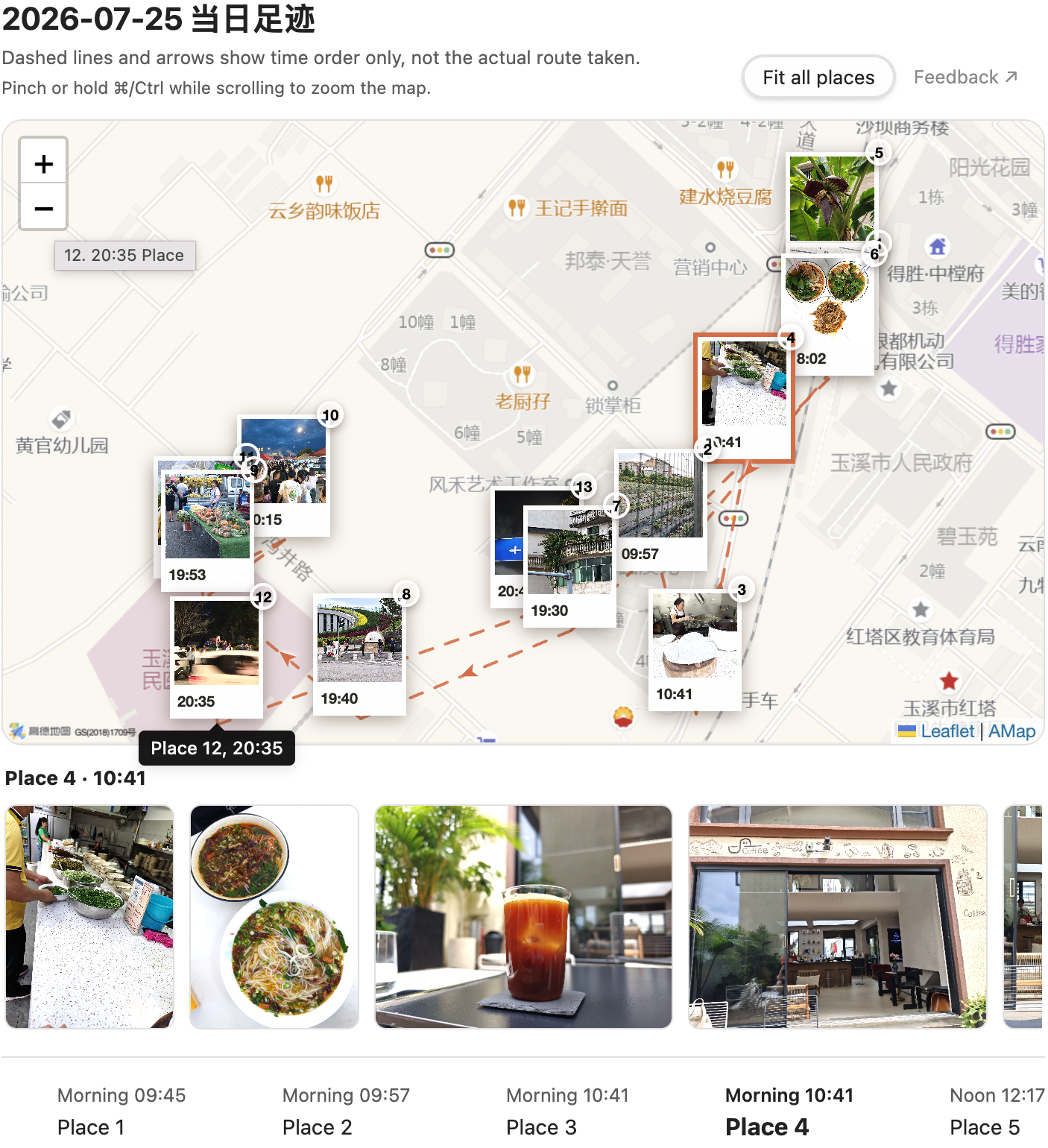
Visualize a day's photo journey on an interactive map, with time-ordered places, photo galleries, and a synchronized timeline.
Map data © OpenStreetMap contributors
Features
- Generate visits from embedded JPEG, HEIC, and PNG photo metadata.
- Group consecutive photos within 200 metres of the first photo into one place.
- Render with OpenStreetMap, an AMap static basemap, custom raster tiles, or no basemap.
- Keep photo markers, the timeline, and order lines available when a basemap fails.
- Browse every photo associated with the selected place.
- Click a photo in the browser strip to open a large preview. Scroll or pinch to zoom from 1× to 6×, and drag the enlarged photo to inspect it; close with Escape, the backdrop, or the close button.
- Fit AMap views in quarter-step increments while keeping photo cards visible and the integer-level static image correctly aligned.
- Store footprint data in GeoJSON next to the note instead of a proprietary database.
- Share lightweight product feedback from the plugin settings or beside Fit all places in a rendered map header; the third-party form opens only after a user click.
- English and Simplified Chinese interface.
Requirements
- Obsidian 1.11.5 or later.
- Photos need GPS metadata and a timestamp with an explicit UTC offset to be imported automatically.
- Network access is needed for an online basemap and when the user chooses to open the optional feedback form. Footprint data and photos remain usable without either.
Installation
Community plugins
After the plugin is accepted into the Obsidian community directory:
- Open Settings → Community plugins.
- Search for Footprint Map.
- Select Install, then Enable.
Manual installation
- Download
main.js,manifest.json, andstyles.cssfrom the same GitHub release. - Create
<your-vault>/.obsidian/plugins/footprint-map/. - Put the three files in that directory.
- Reload Obsidian and enable Footprint Map under Community plugins.
Do not copy another person's data.json; it contains vault-specific preferences and secret references.
Markdown format
```footprint-map
source: 2026-07-17.footprint.geojson
height: 520
title: Daily footprint
tiles: true
tileProvider: osm
```
source and fallback are resolved relative to the current note. tileProvider supports osm, amap, and custom. If it is omitted, the plugin setting is used. Set tiles: false to prevent all online basemap requests while retaining markers, the timeline, and connecting lines.
Basemaps
OpenStreetMap
OpenStreetMap is the default and works without an API key. The plugin displays the required attribution and requests only tiles for the viewport being viewed. It does not implement bulk download, prefetch, or offline tile packages. The public OpenStreetMap tile service is best-effort and may be unavailable or restrict traffic under its usage policy.
AMap
AMap is optional and intended mainly for users in mainland China.
- Create an AMap Web Service API key. A Web (JS API) key is a different credential type and will not work here.
- In Settings → Footprint Map, select or create an Obsidian secret containing that Web Service key.
- Select AMap static map as the default basemap.
The plugin stores only a SecretStorage identifier in data.json. It never writes the AMap credential value to Markdown, GeoJSON, or release files. The old JavaScript API key and security code settings are removed during migration and are not silently reused as a Web Service key.
AMap is requested as a static image after the initial view settles and after a drag or zoom ends. The request is debounced; Footprint Map does not prefetch or bulk-cache AMap images. Photo cards, selection, the timeline, dashed order lines, and arrows are rendered locally by Leaflet and remain interactive. Users are responsible for their own AMap account, key restrictions, quotas, and provider terms.
Custom tiles
Advanced users may provide an HTTP(S) raster tile URL containing {z}, {x}, and {y}, the provider's required attribution, and a maximum zoom from 1 to 24. Only use a service whose licence and usage policy permit your intended use.
Privacy and network disclosure
Footprint Map has no account, analytics, advertising, or telemetry.
When generating a footprint, the plugin locally reads only the images explicitly embedded in the active note. It extracts GPS and capture time metadata in the Obsidian client. Photo files and EXIF metadata are not uploaded by Footprint Map.
When you run the generation command, the plugin may create or update:
<note-name>.footprint.geojsonnext to the note;- one
footprint-mapcode block in the active note.
Online basemaps necessarily contact third parties:
- OpenStreetMap receives normal tile requests, including the requesting IP address and tile coordinates for the visible map area.
- AMap receives static-map requests containing the user-provided Web Service key, visible map centre, zoom level, requested image size, and the requesting IP address.
- A custom tile provider receives requests for the tiles visible in the current viewport.
Set tiles: false to use no-basemap mode and avoid these basemap requests. Refer to each provider's privacy policy and terms for its own processing practices.
The optional Feedback setting and the subtle Feedback ↗ action beside Fit all places in a rendered Obsidian map header open a third-party Tally form in a separate browser page only after you click them. Footprint Map does not read or send vault contents, photos, coordinates, GeoJSON, settings, or diagnostics when opening the form. Tally receives the normal web request and any information you intentionally enter, under Tally's privacy policy. Do not submit private photos, precise coordinates, API keys, or complete footprint files.
Data ownership and backups
GeoJSON, Markdown, and photo references remain ordinary files in your vault. Back them up as you would any other notes. Disabling or uninstalling the plugin does not delete generated files. Before running generation on important notes, keep a current backup or use version control.
Troubleshooting
- No visits generated: verify that the embedded photos contain GPS and an explicit timezone offset.
- Basemap missing: markers and the timeline should remain available. Check connectivity and the selected provider's configuration.
- AMap fails: confirm that the selected secret contains a Web Service API key, the key is enabled for the static map service, and the account still has available quota. The plugin keeps markers, lines, photos, and the timeline available without a basemap.
- HEIC preview unavailable: the visit remains valid even if the host cannot decode the image. Converting the displayed copy to PNG or JPEG may help.
- Wrong language: choose Auto, English, or Simplified Chinese under Settings → Footprint Map, then reload the plugin.
Development
npm ci
npm run check
npm run package
Production plugin assets are written to release/footprint-map/. The project also builds a standalone browser viewer and a Node.js CLI; those tools are not installed by the Obsidian community plugin package.
CLI example:
node dist/cli/footprint-map.mjs generate \
  --input /path/to/vault/trips/example/logs/2026-07-17.md \
  --vault /path/to/vault \
  --height 520 \
  --tile-provider osm \
  --timezone Asia/Shanghai
The CLI previews changes unless --apply is explicitly provided.
See CONTRIBUTING.md, SECURITY.md, and THIRD_PARTY_NOTICES.md.
Licence
Footprint Map is released under the MIT License. Third-party components retain their own licences as listed in THIRD_PARTY_NOTICES.md.
简体中文
Footprint Map 从 Obsidian 笔记引用的本地照片中读取 GPS 与带时区的拍摄时间,生成按时间排序的互动足迹。地点之间的虚线和箭头只表示先后顺序,不表示实际街道路程。
快速使用
- 安装并启用 Footprint Map 插件。
- 打开 Obsidian 中想要生成 Footprint Map 的笔记。
- 将光标放在地图要出现的位置,按
Command + P打开命令面板,搜索Footprint,选择 Footprint Map:从当前笔记的照片生成足迹;代码块会插入执行命令时的光标处。地图下方照片栏支持单击打开大图,滚动鼠标或双指捏合可在1×–6×之间缩放,放大后可以拖动查看;用Esc、背景或关闭按钮退出。
注意事项
以下情况可能会导致图片无法展示在 Footprint Map 的结果中:
- 网络下载的图片。
- 拍摄时未启用位置信息的照片。
默认底图为 OpenStreetMap,无需 Key。中国大陆用户可以切换高德静态地图,并在 Obsidian 安全存储中选择或创建包含“Web 服务 API Key”的凭据;旧的 Web 端(JS API)Key 不能代替该 Key。高德请求只在视野稳定或拖动、缩放结束后防抖发起;点位、连线、照片和时间轴仍在本地渲染。高级用户也可以使用自定义瓦片,或设置 tiles: false 完全关闭在线底图。
插件不包含遥测、广告或账户系统。照片与 EXIF 在本地读取;启用在线底图时,当前视野对应的瓦片请求会发送给所选地图服务商。禁用或卸载插件不会自动删除已生成的 GeoJSON 或 Markdown 内容。
设置页中的可选反馈入口,以及 Obsidian 地图面板标题区右上方、“适配全部点位”旁边的次级“反馈 ↗”操作,仅在用户点击后才会在独立浏览器页面打开第三方 Tally 表单。打开表单时,Footprint Map 不会读取或发送 Vault 内容、照片、坐标、GeoJSON、设置或诊断信息;Tally 会按照其隐私政策接收普通网页请求以及用户主动填写的内容。请勿提交私人照片、精确坐标、API Key 或完整足迹文件。
项目使用 MIT License 开源;第三方组件许可声明见 THIRD_PARTY_NOTICES.md。