Search...Search plugins and themes...
⌘K
Sign in
  • Get started
  • Download
  • Pricing
  • Enterprise
  • Account
  • Obsidian
  • Overview
  • Sync
  • Publish
  • Canvas
  • Mobile
  • Web Clipper
  • CLI
  • Learn
  • Help
  • Developers
  • Changelog
  • About
  • Roadmap
  • Blog
  • Resources
  • System status
  • License overview
  • Terms of service
  • Privacy policy
  • Security
  • Community
  • Plugins
  • Themes
  • Discord
  • Forum / 中文论坛
  • Merch store
  • Brand guidelines
Follow us
DiscordTwitterBlueskyThreadsMastodonYouTubeGitHub
© 2026 Obsidian

Advanced Maps

Jin1cJin1c62 downloads

Supercharge the built-in Maps view: GPX/GeoJSON tracks drawn from note embeds, zoom-to-fit, GCJ-02/BD-09 tile alignment, inline rendering for ![[track.gpx]], and coordinates from a pasted map link, a place search or your device.

Add to Obsidian
  • Overview
  • Scorecard
  • Updates14

English · 简体中文

Adds to Obsidian's built-in Maps view instead of replacing it: GPX tracks, Chinese coordinate systems, inline maps, and three ways to fill in a note's coordinates. Everything the built-in view already does — markers, icons, colours, tiles, popups — stays the built-in view doing it. No Leaflet, no vendored map library, no runtime dependencies.

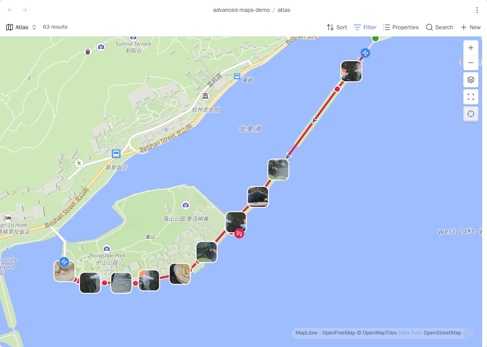
A Bases map view on a mainland basemap: a 13.6 km GPX loop drawn from a note's embed, with each note's pin in its own colour

What it fixes

Problem What this plugin does
A note has a .gpx attached, and the map shows only a pin. Draws the track, in that note's colour, with start/end pins and direction arrows.
The .gpx knows how far you walked, and nothing tells you. Distance, ascent, moving time and pace, with a hoverable elevation profile.
Mainland basemaps aren't WGS-84, so every pin floats a few streets. Converts on the way to the map and back. Nothing on disk changes.
The map opens on the whole world. Auto-frames markers and tracks, and gets out of the way once you pan.
![[track.gpx]] renders as a link. Renders it as a real map, inline.
A map beside the note you are editing drifts away from it. Press ⊹ and it follows the note you switch to. The base's query is never touched.
A trip note is about six places, and a note holds one coordinate. One line embeds a map of the notes around it. Drag a note in and it appears.
A share link, and you have to dig the numbers out — in which datum? Paste it. WGS-84 comes out, whatever went in.
Filling in coordinates by hand. Search a place name, or take it from where you are — on desktop too.

Requirements

Obsidian 1.13.1+, Bases enabled, and the first-party Maps plugin — that is the view this one extends. Without it Advanced Maps says so and does nothing.

Install

From a release. Drop main.js, manifest.json and styles.css from Releases into <vault>/.obsidian/plugins/advanced-maps/ and enable it.

With BRAT. Add Jin1c-3/obsidian-advanced-maps.

Tracks

Attach a .gpx, .geojson, .kml or .tcx to a note and any map view whose base includes that note draws the track. Nothing to configure, and no need to widen a filter to let attachments into the result set.

The ! decides whether the note also gets a map of its own: ![[walk.gpx]] gives you the line on every base map and an inline map in the note; [[walk.gpx]] — or a track: "[[walk.gpx]]" property — gives you only the line.

Every track carries a start pin, a differently-shaped end pin, and arrows showing which way it went. Named waypoints show their name on hover, inline. Show track markers turns all of it off.

A GPX track across a causeway: a green disc where it started, a red ring where it ended, and arrows along the line pointing the way it was walked

Inline maps

The same embed renders as a real map in the note — pan it, zoom it, switch its background — with the numbers the file was carrying all along underneath.

A note with an embedded .gpx rendering as a live map, distance, ascent, times and pace on a line below it, and an elevation profile under that

Distance, ascent and descent, elevation range, elapsed and moving time, pace. Whatever the file does not record is left out rather than shown as zero. Hover any number to see what it is; hover the profile and a point moves along the track on the map, and the other way round. Both the line and the profile can be switched off.

Two numbers are set the careful way: ascent ignores drift under 5 m, because raw GPS elevation is noisy enough to invent hundreds of metres of climb, and moving time counts anything above 0.9 km/h, low enough that walking up steps still counts as walking.

View options

The built-in options are untouched; two groups are appended — Tracks behind Markers, Coordinate system behind Background.

Option Meaning
Line width Track stroke width
Line opacity Track stroke opacity
Max zoom when fitting Upper bound for auto-fit
Tile coordinate system Blank follows the plugin setting

Coordinate systems

The same WGS-84 track on the same basemap, with the conversion off and then on: it moves from the hillside back onto the causeway it was walked along

Both frames are the same .gpx on the same tiles. Off, the walk runs over 宝石山; on, it lands on 白堤 — about 520 m, and every pin moves with it.

Leave it on Auto and the system is read off the tile URL: mainland hosts serving GCJ-02 or BD-09 are recognised by name, everything else is WGS-84. Set a default in settings, or force one per view when a proxied URL can't reveal where it came from.

Open a spot in another map app

Right-click a map. Alongside the built-in items is Open in external map.

The map's right-click menu, with "Open in external map" opening a submenu of Amap, Baidu, Tencent, Google, Apple and OpenStreetMap

Each app is sent the datum it expects, converted from the spot you clicked: GCJ-02 to Amap and Tencent, BD-09 to Baidu, WGS-84 or GCJ-02 to Google and Apple depending on whether the point is inside China. That is the whole difficulty — the same six links built naively land wrong in three different ways, none of them visible until you are standing in the wrong street.

Reorder the six under Open in external map in settings, switch off the ones you never reach for, or switch all six off and nothing is added to the menu. Your own starts empty; an entry is a name, a URL and the datum that URL expects:

https://ul.waze.com/ul?ll={lat},{lng}&navigate=yes      WGS-84
https://www.bing.com/maps?cp={lat}~{lng}&lvl=16         WGS-84
om://map?v=1&ll={lat},{lng}                             WGS-84

App schemes work too — waze://, iosamap://, comgooglemaps://. The datum is stated rather than guessed, because a mirror of a Chinese provider looks like an ordinary host and getting it wrong does not fail, it just puts the pin a few streets away.

One base, reused everywhere

You keep a single .base file, and every map in the vault is that base seen through a different filter. Pick it once under Base file path — the box lists the .base files in your vault. From then on it answers all three questions a map has to settle:

Question Where the answer lives
Which notes count as places? The base's own filters — a folder, a tag, a property
What does a pin look like? The base's formulas, through Marker icon and Marker colour
Where is the coordinate? The map view's Coordinates property

Tune the look once and every map follows, retroactively, because none of them carry a copy of your base — they reference it. Several unrelated sets of places? A base each is fine; Base file path just names the one the commands use.

Open in map

Notes carrying the coordinate property (coords by default) get an Open in map entry on their ⋮ menu. It is your base, with your filters and icons — the camera moves to that note and its popup opens. Nothing is copied or rewritten.

A base's map view opened on one note: the camera on 楼外楼, its own pin and popup, the other places of that base still around it

Open in picks where it lands. A tab opens the base file itself, reusing a tab already showing it, so pressing this on one note after another is a single map that keeps moving — and because it is the real file, changes you make on the map are kept. A pop-up leaves your layout alone, at the cost of having nowhere to write a view option back to.

Follow the active note

Every map carries a ⊹ button next to zoom-to-fit. Press it and that map pans to whichever note you switch to and opens its popup. Your zoom is left alone, and the base's query is never touched: only the camera moves.

A note in one tab and the same base's map in the next one over, panned to that note's coordinate with its popup open and the follow button lit

It is per map, not per plugin — a map in a sidebar and a map in the tab beside your note can follow while the one you are reading in another tab sits still. A following map also stays out of your way: the popup opens without taking the caret out of your editor, and clicking a pin opens that note in the pane the map is following rather than replacing the map with it. New maps follow the active note sets which way the button starts.

A map of the notes around a note

Insert a map of the notes around this one writes a single line into the note you are in:

![[places.base#Around]]

A trip note whose places are ordinary links, with a map underneath showing each of them as a pin

It is a view in your own base, filtered to the notes this one links to, the notes that link to it, and the note itself. Drag a note into the body — Obsidian makes a link, the way it always does — and it appears on the map. Delete the link and it goes. There is no list to keep: the links around the note are the map.

The view is added to the base the first time and referenced after that, so a later change to the base reaches every map already inserted. Two edges: the link names the view, so renaming it in Bases makes inserted maps stop resolving quietly, and the base's own filters still apply, so a note kept outside a folder-scoped base can collect other notes onto a map but not put itself on one.

Filling in coordinates

From a map link

A location almost never arrives as a coordinate — it arrives as a share link. Set coordinates from a map link takes one and fills the property.

The paste box, having read a share link and showing the WGS-84 coordinate it will write

It reads the share links the common mainland and international apps produce, plus geo:30.26,120.15, DMS (30°15'39"N 120°08'49"E) and plain 30.26,120.15. Each shape is read by its own rules, because they disagree about both axis order and datum. Whatever goes in, WGS-84 comes out, and the datum is shown before anything is written.

The box opens with your clipboard already in it. Shortened links hold no coordinate until they are resolved, and this plugin will not quietly hand your link to a third party to do it.

By searching for the place

Search for a place and set coordinates looks a name up and writes what comes back, in your own Obsidian language.

The search box, showing ten places of the same name across four countries, each with its address underneath

Two sources: an open worldwide one that needs no signing up but is thin on mainland places, and a mainland one that needs a free web-service key and knows them far better. A source that answers in GCJ-02 is converted on the way in.

The key goes in secret storage (Obsidian's own — never synced or committed, and stays on the one device) or in plugin settings (one entry covers every device, in plain text). New installs start on secret storage; a key you had before this existed stays where it was until you move it.

From coordinates, backwards

Fill place name from coordinates reads the coordinate property and writes back an address, into Place property (default location). It reuses whichever provider and key place search is set up with. Point both settings at the same property and it refuses rather than overwriting the coordinate it just read.

From where you are

Switch on Enable location and a note whose coordinate property is present but empty gets filled in with where you are — give a template an empty coords: and every note made from it is stamped. Something already there is never overwritten, and a note without the property never gains one. Fill coordinates from current location overwrites on demand.

Values are written as lat,lng in WGS-84. Paths matching Skip paths containing (default templates) are left alone. It works on desktop as well as mobile, where the plugins before this one gave up — current Chromium asks the operating system, so no API key is involved. That still needs the OS location service on, so the plugin asks once and stops asking for the session if the platform refuses.

What leaves your vault

Your notes and your tracks never go anywhere on their own. The one exception is a coordinate you deliberately hand to Fill place name from coordinates.

When What goes out To
Any map is on screen Tile requests, so your IP and the area you are looking at Whichever background the view is set to
You type in the search box The words you typed, your language, your key if you set one The search source you picked
You run Fill place name from coordinates The one coordinate you ran it on The search source you picked
You pick Open in external map The one spot you right-clicked, in that browser tab The map app you chose, in your browser
You switch on Enable location Nothing leaves — the fix comes from the operating system —

No telemetry, no update ping, no server of its own. Two things worth knowing if you are deploying this for other people: a search key appears in the request URL wherever you keep it — secret storage keeps it out of the settings file, not out of the query — and a note's coordinate history can be personal information in a way a note's text is not.

Attribution

The screenshots were taken against third-party basemaps and search services to show what the plugin does; each image carries its source. The demo vault behind them is synthetic — the places and the trail are openly published data, and nothing personal is shown.

The plugin ships no map data of its own. It draws whatever tiles the view is configured with, and their copyright and licensing are the tile provider's and the user's. If you hold rights in anything reproduced here and would rather it were not, open an issue and it will be removed promptly.

Development

git clone https://github.com/Jin1c-3/obsidian-advanced-maps
cd obsidian-advanced-maps
npm install
cp .env.example .env      # point OBSIDIAN_PLUGIN_DIR at a vault
npm run dev               # watch, rebuild into that vault, hot-reload
npm run check             # prettier, eslint, tsc, vitest — the same set CI runs

npm run dev drops a .hotreload marker beside the build, which is what pjeby/hot-reload watches for. You need a vault with Bases on and the first-party Maps plugin installed.

  • ROADMAP.md — what might come next, and what deliberately will not.
  • CLAUDE.md — architecture, the internals this leans on, and the non-obvious things not to undo.
  • CONTRIBUTING.md — setup, tests, house rules, translations.

New language: one object in src/i18n.ts plus one line in LOCALES. English is the source of truth and its keys are the type, so a missing entry is a compile error.

Licence

MIT.

HealthExcellent
ReviewSatisfactory
About
Extend Obsidian's Maps view with GPX/GeoJSON track drawing, inline ![[track.gpx]] maps, and auto zoom-to-fit for markers and tracks. Convert mainland China coordinates to WGS-84, open a note centered on the map, and fill a note's coordinates from share links, place search, or your current location, including desktop.
VisualizationAttachmentsNavigation
Details
Current version
1.11.0
Last updated
3 hours ago
Created
4 days ago
Updates
14 releases
Downloads
62
Compatible with
Obsidian 1.13.1+
Platforms
Desktop, Mobile
License
MIT
Report bugRequest featureReport plugin
Author
Jin1cJin1cjin1c-3
GitHubjin1c-3
  1. Community
  2. Plugins
  3. Visualization
  4. Advanced Maps

Related plugins

Breadcrumbs

Visualise the hierarchy of your vault using a breadcrumb trail or matrix view.

Strange New Worlds

Reveal networked thought and the strange new worlds created by your vault.

Image Context Menus

Image context menus (mostly on right click): Copy to clipboard, Open in default app, Show in system explorer, Reveal file in navigation, Open in new tab.

Graph Banner

Display a local graph view to the note header

Map View

An interactive map view for your notes.

Notebook Navigator

A better file browser and calendar inspired by Apple Notes, Bear, Evernote and Day One.

Excalidraw

Visual PKM powerhouse. Create and edit Excalidraw drawings.

Homepage

Open a note, base, or workspace on startup, or set it for quick access later.

Advanced Canvas

Supercharge your canvas experience. Create presentations, flowcharts and more.

Share Note

Instantly share/publish a note, with the full theme and content exactly like you see in Obsidian. Data is shared encrypted by default, and only you and the person you send it to have the key.