Life Map
 沫语44 downloads
Plot notes, GeoJSON, CSV and any JSON API on one map, with layers, filters, clustering, photo wall and timeline.
- Overview
- Scorecard
- Updates6
简体中文 · English
Website: https://life-map-site.pages.dev · Repository: https://github.com/moyanmoyu/obsidian-life-map
A general-purpose map view for Obsidian: plot places from notes, GeoJSON, CSV or any JSON API on one map that works well in mainland China.
- Note properties: notes with coordinates show up automatically
- GeoJSON / CSV: drop the files into your vault
- Any HTTP API: declarative JSONPath mapping, no code
- Place aggregation: notes at the same spot merge into one marker, each visit is a sub-record
- Layers: stack multiple sources, toggle each one, colour-code by source
- Search & filter: free-text search plus date range
- Clustering: automatic when pins get dense
- Photo wall & timeline in the sidebar, plus a full-screen photo viewer
- Inline maps: render a small map inside a note with a
life-mapcode block - Open from the map: click a pin to jump back to its note
- Export: current filtered view to GeoJSON or a Markdown table
Screenshots
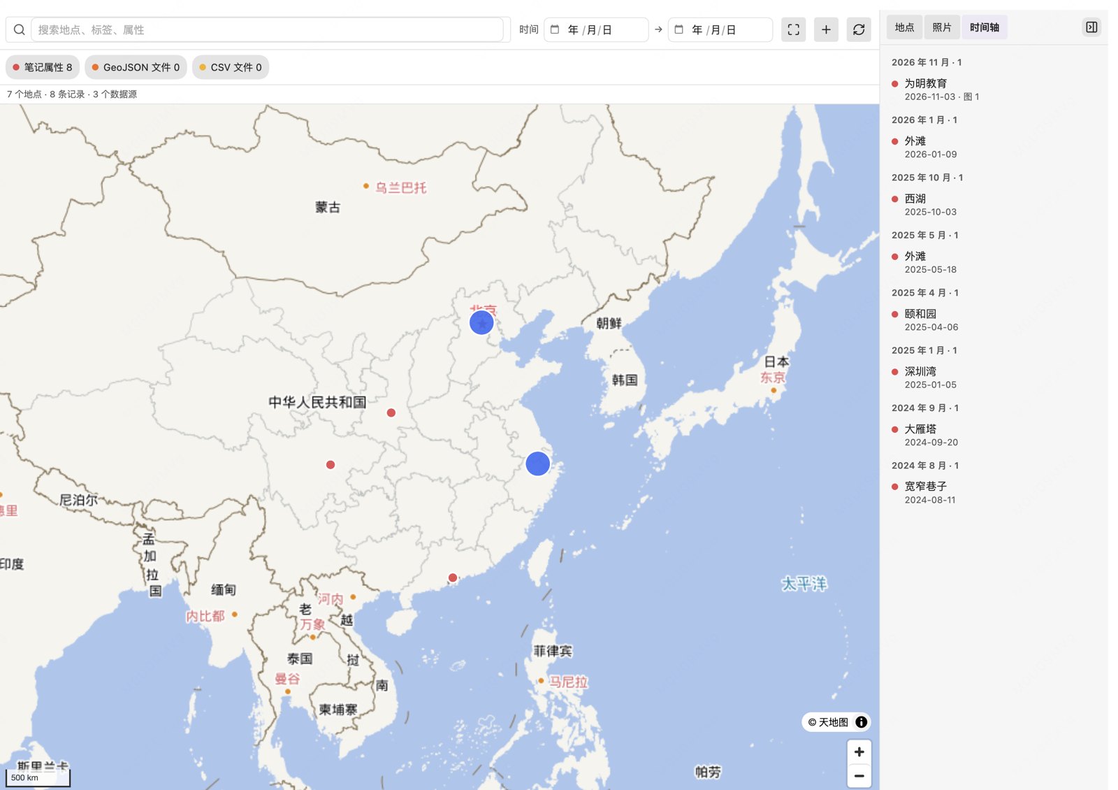
Map view with clustering and the sidebar timeline:
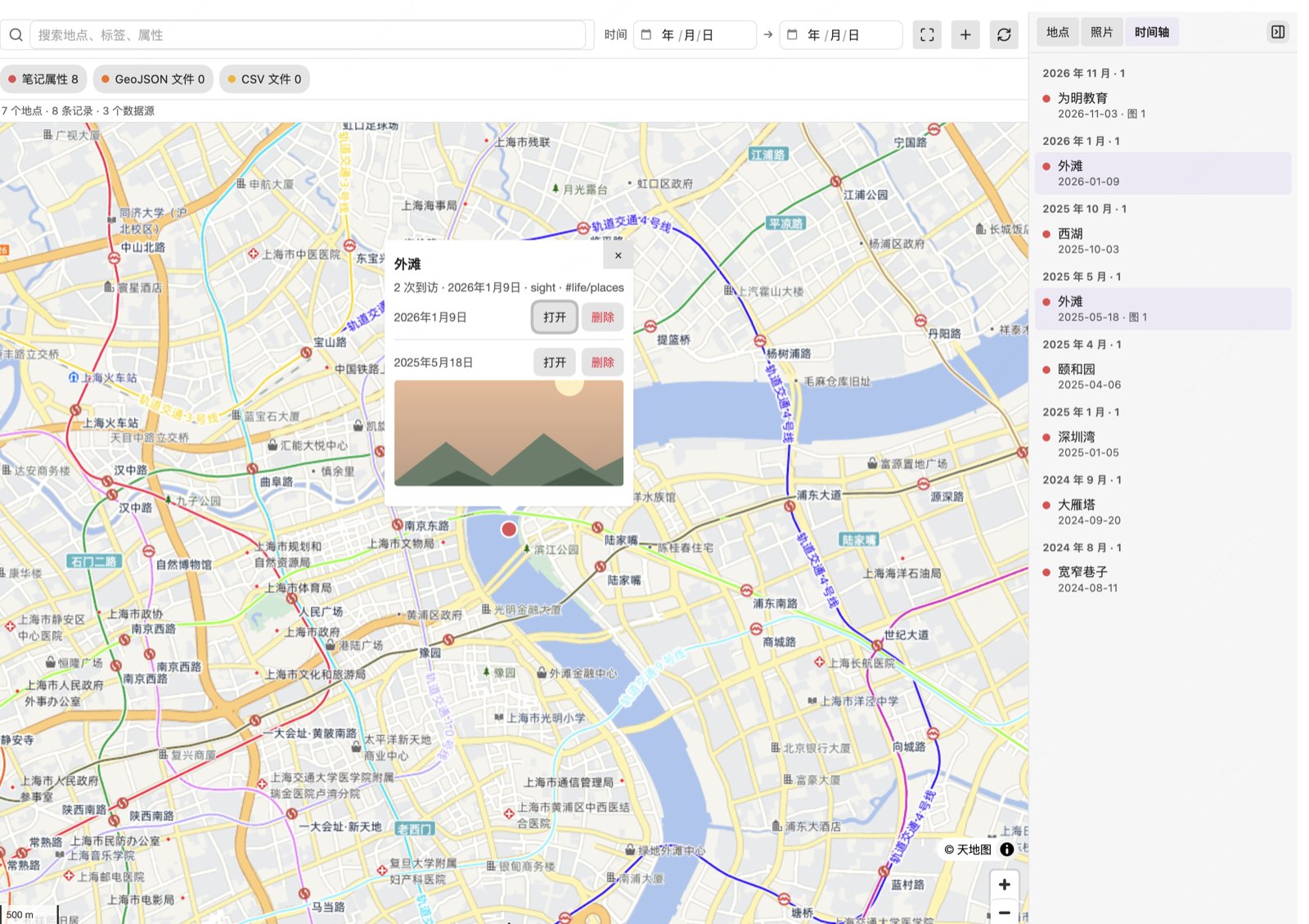
One place, multiple visits (each visit is a sub-record you can open or delete):
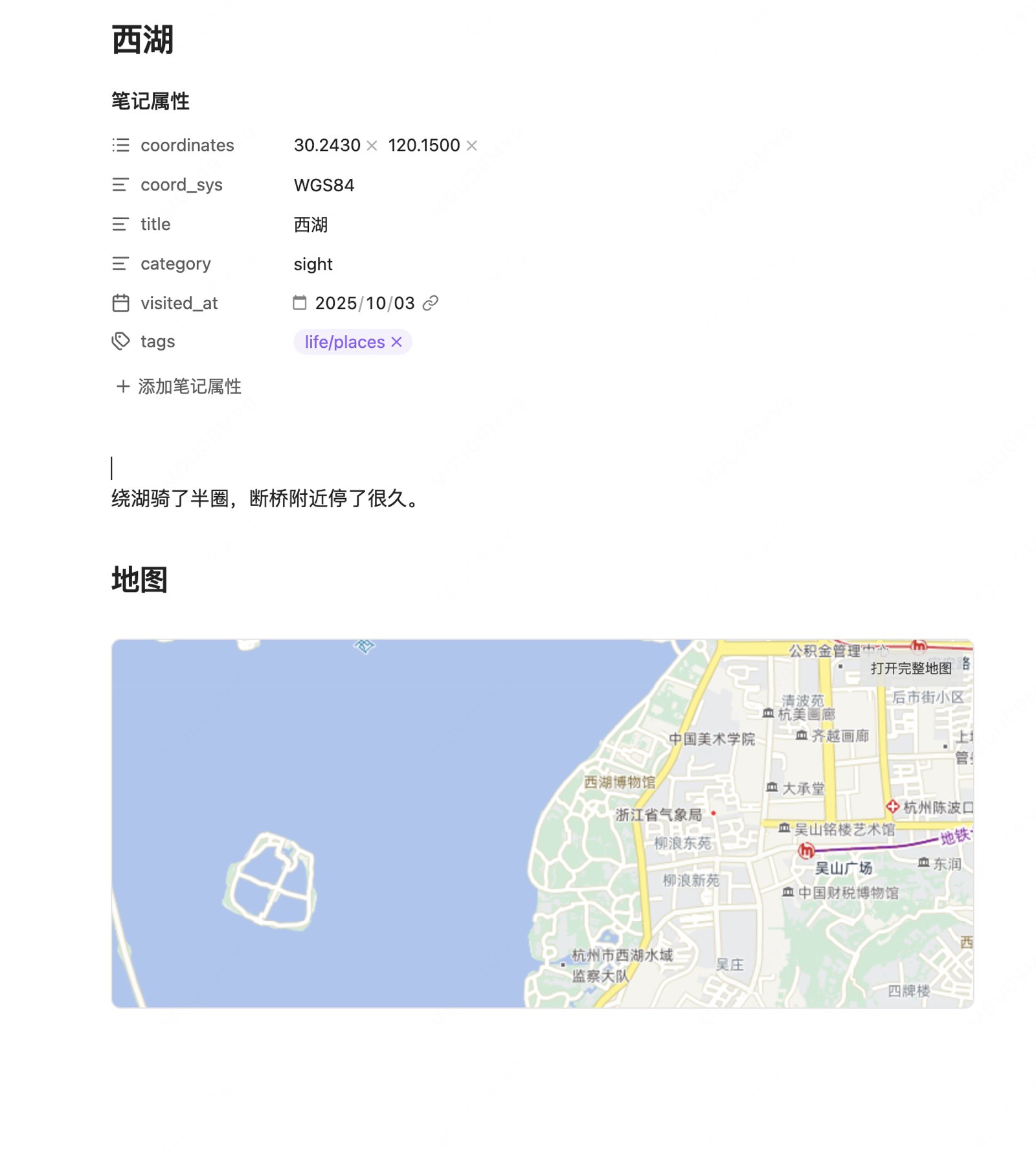
Inline map inside a note:
Installation
Community directory
Not listed yet — use the manual method below for now.
Manual
npm install
npm run build
npm run deploy -- /path/to/your/vault
Then in Obsidian: Settings → Community plugins → disable Safe mode → enable Life Map.
A map icon appears in the ribbon; you can also run Life Map: Open map view from the command palette.
Creating a place note
Option 1: command (recommended)
Run Life Map: New place note from the command palette, or click the + button in the map toolbar, then fill in:
| Field | Notes |
|---|---|
| Name | Note title and filename |
| Latitude / Longitude | Separate fields; negative for south/west |
| Coordinate system | GCJ02 for AMap/Tencent, WGS84 for GPS/GeoJSON |
| Category | Optional |
It creates and opens a note like this:
---
coordinates: ["40.049600", "116.280700"]
coord_sys: GCJ02
title: "Some place"
category: "food"
tags:
  - life/places
---

## Map

```life-map
The target folder is configurable in **Settings → New note folder** (default `10-生活/地点`); duplicate names get `-2`, `-3`.

### Option 2: by hand

Create a note with frontmatter:

```yaml
---
coordinates: ["39.9042", "116.4074"]
coord_sys: WGS84
title: Some place
tags: [life/places]
---
Then add a life-map code block.
Quick start
Add coordinates to any note:
---
coordinates: ["39.9042", "116.4074"]
title: Example place
category: food
visited_at: 2025-03-02
tags: [life/places]
---
Open the map view and the pin appears.
Inline maps
Add a life-map code block to any note to render a small map in place:
```life-map
center: 40.0496, 116.2807
zoom: 14
height: 280
tag: life/places
interactive: false
```
| Option | Default | Description |
|---|---|---|
center |
the note's own coordinates | [lat, lng] or "lat,lng", interpreted as WGS-84; falls back to a country-wide view |
zoom |
13 with a center, else 4 |
1–18 |
height |
260 |
120–600 px |
tag |
all | only show places carrying this tag |
limit |
1000 |
max number of markers |
interactive |
true |
false renders a static map |
- When the note has coordinates, it is highlighted with an extra red marker
- Clicking a pin opens the corresponding note
- At most 6 inline maps per page (each one holds a WebGL context)
- "Open full map" carries the inline map's viewport and tag filter over; the filter chips can be removed individually
Data sources
1. Note properties (enabled by default)
| Field | Default property | Notes |
|---|---|---|
| Coordinates | coordinates |
["lat","lng"], "lat,lng" or {lat,lng} |
| Fallback coords | latitude / longitude |
used when the above is missing |
| Coordinate system | coord_sys |
WGS84 (default) / GCJ02 / BD09 |
| Name | title |
falls back to the filename |
| Time | visited_at |
used by the date filter |
| Category | category |
|
| Tags | tags |
merged with file tags |
| Cover / photos | cover / photos |
wikilink, vault path or URL |
All property names are configurable.
2. GeoJSON
Drop .geojson files into the vault. Only Point / MultiPoint features are rendered for now.
3. CSV
Drop .csv files into the vault; a latitude and longitude column are required. Column names are auto-detected:
| Field | Recognised columns |
|---|---|
| Latitude | lat / latitude / y |
| Longitude | lng / lon / long / longitude / x |
| Name | name / title |
| Time | time / date / visited_at |
| Category | category / type |
| Tags | tags / tag |
CSV files without coordinate columns are skipped.
4. HTTP API (configured in settings)
Any JSON endpoint can be mapped declaratively:
{
  "name": "My places",
  "url": "https://api.example.com/v1/pois",
  "headers": { "Authorization": "Bearer xxx" },
  "coordSys": "gcj02",
  "mapping": {
    "list": "$.data.items",
    "id": "$.id",
    "name": "$.title",
    "lat": "$.location.lat",
    "lng": "$.location.lng",
    "time": "$.visited_at",
    "category": "$.type",
    "tags": "$.tags[*]",
    "photos": "$.photos[*].url",
    "link": "$.url"
  }
}
Supported JSONPath subset: $.a.b, $.a[0].b, $.a[*].b (leading $. optional).
Requests go through Obsidian's requestUrl, so no CORS setup is needed on your backend. GET only for now.
⚠️ Tokens in headers are stored in plain text in
.obsidian/plugins/life-map/data.json.
Basemaps
| Basemap | Key required | Notes |
|---|---|---|
| Tianditu (default) | tk |
Compliant, stable in mainland China |
| OpenFreeMap | no | Fast overseas, may be slow in China |
| Custom XYZ | no | self-hosted or corporate tiles |
| AMap (preset) | no | one-click preset; personal use only, redistribution needs an AMap licence |
Tianditu tk
- Register at https://console.tianditu.gov.cn/ and create an app
- Pick the "browser" key type and paste the
tkinto the settings - Tianditu gates requests on the User-Agent: plain
curlgets403 / 301012, while Obsidian (Electron/Chromium) works. If your key is still rejected, switch it to the "server" type
Without a tk the plugin falls back to a keyless basemap and shows a hint — it never fails silently.
Custom tiles
Point it at any https://example.com/{z}/{x}/{y}.png template. Mind the tile coordinate system: AMap/Tencent raster tiles are GCJ-02, Tianditu/self-hosted are usually WGS-84.
Places outside China
Works fine: transparent coordinates skip the GCJ-02 offset, and OpenFreeMap (or any global tile source) covers the rest. Tianditu is China-focused, so switch to OpenFreeMap if your pins are abroad. The map auto-fits your data on first load, and the toolbar has a "Fit to all data" button.
Extending (plugin authors)
Other plugins can register data sources and basemaps:
const lifeMap = (app as any).plugins.plugins['life-map'];
lifeMap?.api.registerSource({
  id: 'my-src',
  name: 'My data',
  async load() {
    return [{
      id: 'my-src:1',
      sourceId: 'my-src',
      name: 'Some place',
      lat: 39.9042,
      lng: 116.4074,
      coordSys: 'WGS84',
      tags: [],
      photos: [],
      props: {},
    }];
  },
});
API: registerSource / unregisterSource / registerBasemap / refresh / getResults / getFeatures / open.
There is intentionally no user scripting hook — that would be arbitrary code execution. Convert exotic data to GeoJSON/CSV, or write a small plugin.
Deleting records
Each visit in the place popup has a delete button:
- Only vault Markdown notes can be deleted; they go to the trash (recoverable), not permanent deletion
- A confirmation dialog always appears first
- GeoJSON / CSV / HTTP sources are read-only and have no delete button
- The map, sidebar and counters refresh automatically afterwards
Commands
| Command | What it does |
|---|---|
Life Map: Open map view |
open / focus the map |
Life Map: New place note |
form-driven note creation |
Life Map: Refresh map data |
reload every source |
Life Map: Export view as GeoJSON |
export the current filtered view (WGS-84) |
Life Map: Export view as Markdown table |
export the current filtered view |
Compatibility
| Item | Notes |
|---|---|
| Minimum Obsidian | 1.7.2 |
| Desktop | macOS / Windows / Linux |
| Mobile | iOS / Android (basic support) |
| Offline | data sources work offline; basemaps need network or cached tiles |
Network access and privacy
No telemetry, no auto-update mechanism. Network access only happens for:
| Purpose | Host |
|---|---|
| Tianditu tiles | t0–t7.tianditu.gov.cn |
| OpenFreeMap tiles | tiles.openfreemap.org |
| Custom tiles | whatever you configure |
| HTTP data sources | whatever you configure |
Credentials are stored locally in .obsidian/plugins/life-map/data.json (plain text). No note, photo or coordinate is ever collected or uploaded.
Two behaviours worth knowing about (shown in the community directory's automated review):
- Vault enumeration — to find
.geojson/.csvfiles, the plugin lists vault file paths (vault.getFiles()). It only reads the contents of files whose extension matches an enabled data source; disable the GeoJSON / CSV sources in settings to skip this scan entirely. - Clipboard — the "copy example" button in the empty state writes to the clipboard. The plugin never reads the clipboard.
Known limitations (v0.9)
- Points only — no polylines (GPX tracks) or polygons
- Full reload on each refresh, no incremental sync
- Recommended up to ~20,000 places
- Photos are shown as thumbnails / lightbox, no album management
Development and releasing
- Development: environment, commands, project layout, tests and pitfalls
- Releasing: version consistency, release flow, how not to ship your map key
- Website: the static portal and Cloudflare Pages deployment
License
MIT